To understand recent transformations in Shanghai it is critical to understand the short history of the city. Here is a brief summary:
History of Shanghai
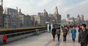
Prior to the 1842 Treaty of Nanking ending the first Opium War, Shanghai was a rural fishing village along the Huangpu River. As part of the treaty concessions, Shanghai along with the four other coastal cities of Xiamen, Fuzhou, Ningbo and Guangzhou were selected by the British to become treaty ports. The British and Americans were quick to develop the fishing village of Shanghai into the “Paris of the East”. Exempt from all local laws the foreigners were able to create a city in a western style. By the 1900’s the international image of Shanghai’s financial success became The Bund – the waterfront boulevard along the west bank of the Huangpu River. The hotels, banks and trade houses along the Bund were designed by foreign architects and in the neoclassical style popular at the time in Europe and the United States. To the Chinese populace The Bund also became a symbol of foreign dominance.

The Bund 2009
The Chinese began developing various plans to reclaim the symbolic heart of Shanghai as far back as Sun Yat-sen’s initial plan of 1919. Many plans have involved the undeveloped east bank of the Huangpu River, known as Pudong (Pu referring to the Huangpu river and Dong meaning east in Chinese), but these plans for Pudong were considered too ambitious and the focus remained on Puxi, the area of the existent city. Attempts to create new civic centers Puxi all ended with results less than hoped for and these new developments were unable to unseat The Bund as Shanghai’s symbolic center.
In the mid 1980’s China as a nation began to open itself up to foreign investment with the Open Door Policy. The opening of the nation to foreign investment followed the three decades of isolationist policy under the leadership of Mao Zedong. Eyes turned again to Pudong and in 1990 this area of farmland and villages was named a Special Economic Zone (S.E.Z.) by the Chinese Government. China now had its chance to redefine the global image of Shanghai.

View of Pudong in 1990. The Bund in foreground.
Pudong was divided into several development areas with Lujiazui, the area directly across the river from the Bund, designated as the new financial hub of China. A team of French urban planners hired as consultants suggested three closely placed signature towers surrounded by many secondary high rise buildings would be a winning formula for developing a memorable skyline. Since one of the major ambitions of the Pudong development was to create a new symbolic image of Shanghai, this plan had great promise to city officials.

Pudong viewed from The Bund 2009
Visiting Shanghai I found it hard to perceive the scale of the recent development and growth of the city. Everywhere I traveled there seemed to be buildings under construction, new overhead highways and recently completed bridges across the Huangpu, but I was only seeing portions of what was happening. Even from the top of the World Financial Center the scope of the city’s growth was obscured by overcast skies.

View of Puxi from World Financial Center
Finally when visiting the Shanghai Planning Museum and seeing the city model I understood the scale of the transformation. I was overwhelmed by both a sense of excitement and fear. Excited by the transformations and everything new in the city and a fearful that the city is growing too quickly and perhaps blindly.

Shanghai Planning Museum
Thomas J. Campanella , “The Concrete Dragon” (New York, Princeton Architectural Press, 2008) was referenced in writing the above entry on the history of Shanghai.
Recent Comments